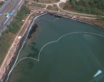
Accidents involving spilled oil are frequent occurrences in coastal regions. Many factors including, winds, surface currents, tides, air and water temperatures, and salinity, control the movement of spilled oil. The type and amount of spilled oil, and local shoreline and bottom features also influence movements of an oil slick. An effective response to an oil spill requires the input of scientists representing many different specialties and information on the chemical composition of the spilled oil, ocean currents, and weather. These data are needed for mathematical models that predict movements (known as trajectory analysis) of the oil. When combined with biological resource information, trajectory analyses can be used to identify areas that are most vulnerable to the oil so that equipment to contain the oil spill can be dispatched to where it will be most effective. Sensitive areas requiring protection include marine sanc- tuaries and unique habitats, especially those that are home to endangered species. Protection is key because oil not only causes immediate contamination but also has long- term effects on coastal ecosystems. The National Oceanic and Atmospheric Administration (NOAA) Coastal Change Analysis Program uses remote sensing data, primarily aerial photography, to identify and classify sensitive habitats of bottom-dwelling organisms, such as sea grasses. Oil spills can affect sea grasses in many ways. Toxic materials in the spilled oil are introduced into sediments, the water, and ultimately living organisms. Oil can also block sunlight from reaching the plants. Heavy oils sink and mix with sediment and can coat sea grasses. When these grasses are damaged or killed, organisms that depend upon them as a food source or for habitat are also adversely affected. This has a ripple effect on the local ecosystem and ultimately damages economically valuable fish and shellfish, thus impacting local economies for many years. Major sectors of Maine's economy, especially tourism and fishing, require clean coastal waters, aesthetically appealing coastlines, and functioning coastal ecosystems. The state requires timely and appropriate responses to oil spills. To demonstrate the important role of accurate oil-spill trajectory analysis and prompt response to mediate the effects of oil spills, we examine two cases separated by nearly 25 years. In 1972, the tanker Tamano spilled 380,000 liters (100,000 gal) of oil into Casco Bay, near Portland in southern Maine, then the largest oil spill in the state's history. Plans for dealing with spills were antiquated and slow to be implemen- ted. During the several days required to mobilize response teams, the oil spread along about 75 km (47 mi) of coastline, including beaches on 18 small islands, damaging commerci- ally valuable fish and shellfish stocks. The cleanup that followed took 11 years and cost nearly $4 billion. On September 27, 1996, the tanker Julie N. struck a bridge entering Casco Bay, spilling 680,000 liters (180,000 gal) of light fuel oil and much heavier bunker-C, a mix of oils. The light fuel oil evaporated quickly but left behind toxic components. The less toxic but heavier bunker-C sank to the bottom, covering vegetation and wildlife with a thick, sticky coating. The response to this incident was rapid and effective. The damaged tanker quickly docked and was immediately surrounded by floating barriers, called booms, to contain floating oil. Other booms were deployed quickly to prevent oil from reaching vulnerable biological resources or econom- ically valuable locations. Special clean-up vessels skimmed and collected oil from the water surface. Timely response combined with successful predictions of oil movements meant that much of the damage that had occurred 25 years earlier in the same area was not repeated. |
For More Information: http://www.coast.go.kr/coast/manager/noaa/maine/html/oilcase.htm NOAA is responsible for providing both scientific and technical support to the US Coast Guard during an oil spill, and acting as a natural resource trustee to protect and restore those resources impacted by the spill. http://www.nos.noaa.gov/programs/orr/welcome.html NOAA's Damage Assessment and Restoration Program (DARP)
|