

Studies of ocean surface currents play a vital role in our present day understanding of weather and climate through the dynamics of ocean-atmosphere interaction. Technology enables us to bridge vast distances, as a result, the oceans are now accessible from every teacher’s classroom and internet user's computer. Real-life challenges and the excitement of ocean exploration can be brought to students of all ages, in every corner of the world, including land-locked locations. Spurred by the need for better weather and climate forecasts, the meteorological and oceanographic communities have expanded their monitoring of wind, temperature, currents, and density structure above and within the ocean. These observations utilize more sophisticated techniques than visual observations from ships of opportunity traversing limited regions of the ocean. Today, sensors on moored and drifting automated buoys and orbiting satellites as well as ships at sea gather wind, temperature, current, and density data.  Real-time data from moored ocean buoys for improved detection,
understanding and prediction of El Niño and La Niña. Moored buoys, deployed by various nations in their coastal waters, serve as instrumented platforms for making automated weather and oceanographic observations. The National Data Buoy Center (NDBC), part of the NOAA National Weather Service, operates approximately 70 moored buoys in the coastal and offshore waters of the western Atlantic Ocean, Gulf of Mexico, and the Pacific Ocean from the Bering Sea to southern California, around the Hawaiian Islands, and in the South Pacific, as well as the Great Lakes. Buoys are equipped with accelerometers or inclinometers that measure the heave acceleration or the vertical displacement provided to the buoy by waves passing during a specified time period. An onboard computer uses statistical wave models to process these measurements and generate wind-sea and swell data that are then transmitted to shore stations. These data include significant wave height, average wave period, and dominant wave period during each 20-minute sampling interval. Selected buoys also measure directional wave data, such as mean wave direction. 
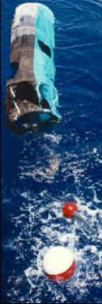
The modern drifter is a high-tech version of the "message in a bottle". It consists of a surface buoy and a subsurface drogue (sea anchor), attached by a long, thin tether. The buoy measures temperature and other properties, and has a transmitter to send the data to passing satellites. The drogue dominates the total area of the instrument and is centered at a depth of 15 meters beneath the sea surface.
More recently, researchers began tracking objects while they were drifting. This tracking was first done visually (from a coastline or anchored ship,) then using radio, and most recently using satellites. During the 1970s, when satellite tracking became possible, many competing drifter designs were proposed, built and deployed in various studies around the world. In 1982 the World Climate Research Program (WCRP) recognized that a global array of drifting buoys ("drifters") would be invaluable for oceanographic and climate research, but there were large differences in the costs and water-following properties of various designs (WCRP, 1988; Niiler, 2001). The WCRP declared that a standardized, low-cost, lightweight, easily-deployed drifter should be developed.
|
This development took place under the Surface Velocity Program (SVP) of the Tropical Ocean Global Atmosphere (TOGA) experiment and the World Ocean Circulation Experiment. Funding was provided by the US Office of Naval Research, the National Oceanic and Atmospheric Administration (NOAA), and the National Science Foundation. Competing designs were rigorously evaluated on a number of criteria including their water-following characteristics, quantified by attaching vector-measuring current meters to the tops and bottom of the drogues (Niiler et al., 1987, 1995). As a result of these examinations, a uniform design for the modern SVP drifter was proposed in 1992 (Sybrandy and Niiler, 1992). The SVP drifter has a spherical surface buoy and a semirigid drogue that maintains its shape in high-shear flows. The modern data set of SVP drifters includes all drifters deployed during the 1979-1993 development period that had a holey-sock drogue centered at 15 m depth. Spar-type drifters with holey-sock drogues were first deployed by NOAA's Atlantic Oceanographic and Meteorological Laboratory in February 1979 as part of the TOGA/Equatorial Pacific Ocean Circulation Experiment (EPOCS). Large-scale deployments of the first modern SVP drifters took place in 1988 (WCRP, 1988) with the goal of mapping the tropical Pacific Ocean's surface circulation. This effort was expanded to global scale as part of WOCE and the Atlantic Climate Change Program (ACCP), in which the array of SVP drifters was extended to cover the Pacific and North Atlantic Oceans by 1992 and the Southern and Indian Oceans by 1994 (Niiler, 2001). The array spanned the tropical and South Atlantic Ocean by 2004 (Lumpkin and Garzoli, 2005). 
Click to enlarge. The status of the global drifter buoy array in February 2007. Red dots represent buoys that measure only sea surface temperature (SST). Blue dots represent buoys that measure both SST and sea level pressure (SLP). Source: http://www.aoml.noaa.gov/phod/dac/dacdata.html A global array of 1250 drifting buoys was completed in September 2005 with the official launch of the 1250th buoy during the Joint WMO-IOC Technical Commission for Oceanography and Marine Meteorology (JCOMM) II conference in Halifax, Nova Scotia. The current status of the global drifting buoy array is shown above. The drifting buoys represent one platform in a larger array of instrumentation monitoring the state of our oceans. Moored buoys, tide gauge stations, profiling floats, and expendable bathythermographs provide detailed information about the upper water column, air-sea fluxes, and surface and atmospheric conditions. The entire array of sensors is part of a larger Global Earth Observation System of Systems, including satellites, where global terrestrial, oceanic, and atmospheric data are collected and shared to help determine the state of our earth and to improve climate and other predictive models. The Atlantic Oceanographic and Meteorological Laboratory (AOML) in Miami, Florida, manages the deployment of drifting buoys around the world, deploying some 300 new drifters annually. Using research ships, Volunteer Observing Ships (VOS), and United States Navy aircraft, Global Lagrangian Drifters are placed in areas of interest. Once considered operational, they are reported to AOML’s Data Assembly Center. Incoming data from the drifters are then placed on the Global Telecommunications System for distribution to meteorological services everywhere. The primary goal of the Global Drifter Program is to provide sea surface temperatures (SST) and surface velocity measurements. These measurements are obtained and shared as part of an international program designed to improve climate prediction. Climate prediction models require accurate estimates of SST to initialize their ocean component and drifting buoys provide essential ground truth SST data for this purpose. Models also require validation by comparison with independent data sets. Surface velocity measurements are used for this validation. CreditsAmerican Meteorological Society's, Diane M. Stanitsky, Shippensburg University Lumpkin, R. and M. Pazos, 2006: Measuring surface currents with Surface Velocity Program drifters: the instrument, its data, and some recent results. Chapter two of Lagrangian Analysis and Prediction of Coastal and Ocean Dynamics (LAPCOD) ed. A. Griffa, A. D. Kirwan, A. J. Mariano, T. Ozgokmen, and T. Rossby. Evolution of Global Drifter Array
|
 For many years, ocean currents have been estimated by how they carry objects.
For example, sailors measured the speed of their ship through the water using
the ship log. They measured their absolute position by celestial navigation
(in the good old days, pre-GPS!). The difference beween the absolute speed
and the speed through the water gave the speed of the currents. Very strong
currents, such as the Gulf Stream of the North American east coast, made
a big difference in how long it takes to travel south versus north! Large-scale
currents were also inferred when an object dropped at one place eventually
washed ashore on a distant beach. Glass balls used by Japanese fishermen
ended up on a beach in California, carried by the vast clockwise-swirling
North Pacific gyre.
For many years, ocean currents have been estimated by how they carry objects.
For example, sailors measured the speed of their ship through the water using
the ship log. They measured their absolute position by celestial navigation
(in the good old days, pre-GPS!). The difference beween the absolute speed
and the speed through the water gave the speed of the currents. Very strong
currents, such as the Gulf Stream of the North American east coast, made
a big difference in how long it takes to travel south versus north! Large-scale
currents were also inferred when an object dropped at one place eventually
washed ashore on a distant beach. Glass balls used by Japanese fishermen
ended up on a beach in California, carried by the vast clockwise-swirling
North Pacific gyre.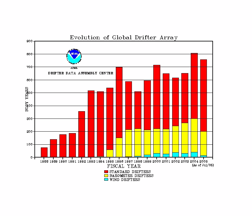