Climate Change
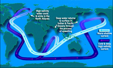
By Edwin Schiele Ocean surface currents redistribute heat around the world and have a profound effect on the world’s climate. Nowhere is this clearer than in the North Atlantic Ocean. The Gulf Stream and the North Atlantic Current ferry huge volumes of warm salty tropical water north to the Greenland coast and to the Nordic Seas. Heat radiating off of this water helps keep the countries of northwest Europe, which are at the same latitude as Labrador and Greenland, relatively comfortable places to live. Many scientists, however, are warning that the North Atlantic might cool down, perhaps by the turn of the century. Paradoxically, global warming would be to blame. Rising temperatures may trigger events that could not only slow the supply of tropical water flowing north, it could disrupt the entire ocean circulation pattern. This scenario has led to wild talk of the start of a new ice age, a notion that climate scientists universally dismiss. Still the impact on the world’s climate could be profound. Scientists are therefore scrambling to gather data on ocean circulation and the forces that drive it. Ocean circulation is comprised of a global network of interconnected currents, counter-currents, deepwater currents, and turbulent eddies. From this complex circulation, an underlying transport pattern emerges. Water cycles from surface currents to deepwater currents then back to the surface again in what scientists liken to a giant conveyor belt. Scientists call this global conveyor belt the meridional overturning circulation. There are two major forces driving the meridional overturning circulation. First there is the wind. The wind, in combination with the Earth’s rotation, generates the gyres that circle the major ocean basins. Turbulent swirling packets of water called eddies, many of which are hundreds of kilometers in diameter, spin out of these wind-driven currents and carry the water trapped inside them to other parts of the ocean. The second force is tied to differences in the density of water. Temperature and salinity independently affect water’s density. The colder and saltier the water, the denser it becomes. As water becomes denser, it sinks. This is where the Atlantic Ocean plays a pivotal role. Again, the Gulf Stream and the North Atlantic Current carry warm salty tropical water up into the Labrador and Greenland Seas. Frigid Arctic winds cool this water, increasing its density. The water then sinks, feeding deepwater currents. This same density driven creation of deepwater also takes place in the frigid Ross and Weddell Seas off the coast of Antarctica, and to a lesser extent in the salty Mediterranean Sea. Scientists call this density-driven component of the meridional overturning circulation the thermohaline circulation; thermo meaning heat and saline meaning salt. Without this density-driven process, deepwater currents would no longer be created. The global conveyor belt would grind to a halt. Scientists are using observations and models to trace the complex pathways of the meridional overturning circulation and determine its strength. It’s an overwhelming task. Maps charting the circulation’s course are still evolving. Deeper currents and upwelling in particular are extremely difficult to measure. But some patterns are becoming clearer. Starting off the Greenland coast, the newly created deepwater slowly drifts south along the western margin of the Atlantic basin. It then crosses the equator and mixes with the deepwater currents circling Antarctica. Models suggest that some of this water resurfaces in this area. Much of it, however, spreads north into Indian and Pacific Oceans where it mixes with warmer water and resurfaces. To close the loop of the conveyor belt, surface water flows from the Pacific and Indian Oceans back into the South Atlantic then heads north. Some cold water enters the South Atlantic from the Pacific around the southern tip of South America. The Agulhas Current in the Indian Ocean is another important source. This fast-moving current, the Indian Ocean’s equivalent of the Gulf Stream, flows down the southeast coast of Africa and past the tip of South Africa then takes a sharp turn to the east. Large eddies called Agulhas Rings spin off this bend and carry huge bundles of warm salty Indian Ocean water west into the South Atlantic. Currents carry much of this Indian Ocean water north to the equator where the sun heats it further. Eventually this water enters the Caribbean and is swept into the Gulf Stream. Scientists believe that these Agulhas Rings are critical sources of the salty water that drives the formation of deep water up north. Eddies spinning out of the Mediterranean Sea and net evaporation in the tropical Atlantic also contribute salty water. Despite its enormous scope, the meridional overturning circulation is vulnerable. Places where deepwater currents are created comprise less than one percent of the ocean’s surface area. Should the temperature or salinity in these limited areas change, the creation of deep water could slow or even stop. There is strong evidence that such a shutdown has happened in the past, drastically altering the world’s climate in just a matter of years. Eleven thousand years ago, ice age glaciers were retreating. In central Canada, an immense glacial lake called Lake Agassiz occupied an area larger than all the Great Lakes. Suddenly the dams holding Lake Agassiz collapsed. The contents of the entire lake rushed into the North Atlantic by way of the St. Lawrence River. This massive infusion of fresh water diluted the polar seas to the point where the water was no longer dense enough to sink. The meridional overturning circulation likely ground to a stop. Called the Younger Dryas, this one thousand year period saw the temporary return of the ice age. We may soon face a similar although far less drastic situation. Scientists are predicting that rising temperatures will melt the Greenland ice sheet. Models suggest that the resulting influx of fresh melt water into the polar sea could weaken the meridional overturning circulation, although not as drastically as the events thought to have triggered the Younger Dryas period. Still it could slow enough to reduce the flow of warm tropical water north into the polar seas. Temperatures over northwestern Europe could drop as much five degrees Celsius. Predictably, talk of such a scenario has led to some big misconceptions. First, a slowdown or even a stoppage of the meridional overturning circulation would NOT spell the end to the Gulf Stream. Wind and large-scale turbulence drive the bulk of the Atlantic Subtropical Gyre, of which the Gulf Stream is a part. The Gulf Stream would, however, draw significantly less water from the tropics. Second, unlike during the Younger Dryas, a weakening of the meridional overturning circulation will NOT trigger another ice age. Rising temperatures due to global warming would offset most of the temperature drop. Armadas of icebergs floating off the New Jersey coast are just Hollywood fantasies. But even in the absence of these most extreme scenarios, any disruption of the meridional overturning circulation can have far-reaching consequences. Models and paleoclimate data suggest that as less warm water flows north across the equator, the southern oceans will warm. The thermal equator (band of highest temperatures) would therefore likely shift south. The tropical rain belts would follow, altering rainfall patterns. Decreased downwelling would deliver less oxygen to the deep ocean, and decreased upwelling would carry fewer nutrients up from the bottom, potentially devastating ocean ecosystems. Monitoring the meridional overturning circulation and identifying changes in the thermohaline circulation is daunting. To separate real trends in ocean circulation from natural variability, scientists require huge volumes of data gathered over a long period of time. A global network of surface and deep profiling ARGO drifters that measure currents, water temperature, and salinity form the backbone of this effort. Moored buoys measure the southbound deepwater currents at strategic locations in the Atlantic. Satellites measure wind, sea surface temperatures, and sea surface height, and programs such as OSCAR calculate surface currents based on these measurements. In 2010, a new satellite, Aquarius, will begin to measure surface salinity throughout the ocean. These observations already form the foundation for global ocean circulation and climate models that are helping scientists predict how the oceans and climate will respond as the Earth warms. |
Pathways associated with the transformation of warm subtropical waters into colder subpolar and polar waters in the northern North Atlantic. Along the subpolar gyre pathway the red to yellow transition indicates the cooling to Labrador Sea Water, which flows back to the subtropical gyre in the west as an intermediate depth current (yellow).
Courtesy NASA/Goddard Space Flight Center Conceptual Image Lab
The Agulhas Current - The animation focuses on the Agulhas current (a major surface current) as it flows around the southern tip of Africa. The small scale eddy structure is resolved and evident. Note the black colors indicate the warmest ocean surface temperatures and and light blues indicate the coolest temperatures. Sea surface temperature (SST) simulation from the Geophysical Fluid Dynamics Laboratory's (GFDL) high resolution coupled atmosphere-ocean model. |